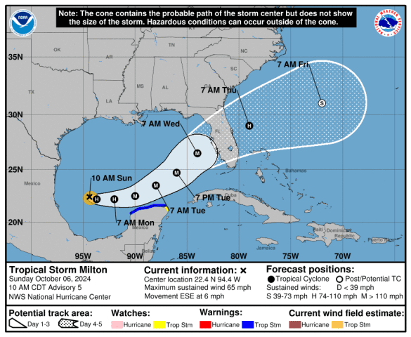
According to the National Hurricane Center (NHC) Tropical Storm Milton is forecast to quickly intensify while it moves eastward to northeastward across the Gulf of Mexico and be a major hurricane when it reaches the west coast of the Florida Peninsula mid week. Users are reminded to not focus on the details of the forecast as there remains significant uncertainty in the eventual track and intensity of Milton.

While it is too soon to specify the exact magnitude and location of the greatest impacts the is an increasing risk of life-threatening storm surge and damaging winds for portions of the west coast of the Florida Peninsula beginning Tuesday night or early Wednesday. Storm Surge and Hurricane Watches could be issued later today or tonight. Residents in the Florida Peninsula should follow any advice given by local officials and check back for updates to the forecast.
Areas of heavy rainfall will impact portions of Florida today and Monday well ahead of Milton, with heavy rainfall more directly related to the system expected later on Tuesday thru Wednesday night. This rainfall will bring the risk flash, urban and area flooding. along with the potential of moderate to major river flooding.
The I-4 Exit Guide is the Internet’s largest and most complete website dedicated to Interstate 4 travelers. Find detailed exit service listings… lodging, camping, food, gas and more for every exit from Tampa to Daytona!
On the road? Why not take us with you. The I-4 Exit Guide is mobile-friendly and totally FREE. No App Required.
Traveling another route? Visit our growing family of exit guides: I-4 Exit Guide, I-5 Exit Guide, I-10 Exit Guide, I-75 Exit Guide, I-80 Exit Guide and I-95 Exit Guide. Detailed exit service listings… discount lodging, camping, food, gas and more for every exit along the way!


